
Caledonia County topographic map
Interactive map
Click on the map to display elevation.
About this map
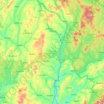
Name: Caledonia County topographic map, elevation, terrain.
Location: Caledonia County, Vermont, United States of America (44.15709 -72.43468 44.76944 -71.83707)
Average elevation: 421 m
Minimum elevation: 123 m
Maximum elevation: 1,245 m
Other topographic maps
Click on a map to view its topography, its elevation and its terrain.
Rutland County
United States of America > Vermont
Rutland County, Vermont, United States of America
Average elevation: 363 m
Chittenden County
United States of America > Vermont
Chittenden County, Vermont, United States of America
Average elevation: 228 m