
Hanglip topographic map
Interactive map
Click on the map to display elevation.
About this map
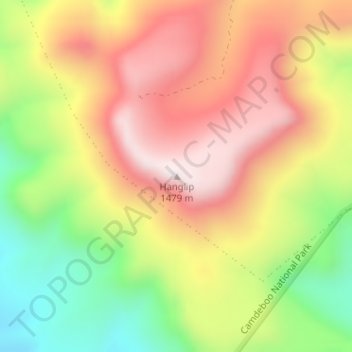
Name: Hanglip topographic map, elevation, terrain.
Average elevation: 1,178 m
Minimum elevation: 832 m
Maximum elevation: 1,481 m
Other topographic maps
Click on a map to view its topography, its elevation and its terrain.
Gats
RSA > Eastern Cape > Camdeboo Local Municipality
Gats, Camdeboo Local Municipality, Sarah Baartman District Municipality, Eastern Cape, RSA
Average elevation: 1,160 m
Swartberg
RSA > Eastern Cape > Camdeboo Local Municipality
Swartberg, Camdeboo Local Municipality, Sarah Baartman District Municipality, Eastern Cape, RSA
Average elevation: 1,198 m
Camdeboo Ward 2
RSA > Eastern Cape > Camdeboo Local Municipality
Camdeboo Ward 2, Camdeboo Local Municipality, Sarah Baartman District Municipality, Eastern Cape, 6280, RSA
Average elevation: 1,416 m