
Fairfax County topographic map
Interactive map
Click on the map to display elevation.
About this map
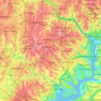
Name: Fairfax County topographic map, elevation, terrain.
Location: Fairfax County, Virginia, United States of America (38.60395 -77.53704 39.05763 -77.04057)
Average elevation: 75 m
Minimum elevation: -3 m
Maximum elevation: 168 m
Most of the county lies in the Piedmont region, with rolling hills and deep stream valleys such as Difficult Run and its tributaries. West of Route 28, the hills give way to a flat, gentle valley which stretches west to the Bull Run Mountains in Loudoun County. Elevations in the county range from near sea level along the tidal sections of the Potomac River in the southeast portion of the county to more than 500 feet (150 m) in the Tysons Corner area.
Other topographic maps
Click on a map to view its topography, its elevation and its terrain.
Hanover County
United States of America > Virginia
Hanover County, Virginia, United States of America
Average elevation: 59 m
Montgomery County
United States of America > Virginia
Montgomery County, Virginia, United States of America
Average elevation: 654 m
Centreville
United States of America > Virginia > Centreville
Centreville, Fairfax County, Virginia, United States of America
Average elevation: 96 m
Smyth County
United States of America > Virginia
Smyth County, Virginia, United States of America
Average elevation: 852 m
Bocock
United States of America > Virginia > Bocock
Bocock, Campbell County, Virginia, 24504, United States of America
Average elevation: 234 m
Frederick County
United States of America > Virginia
Frederick County, Virginia, United States of America
Average elevation: 288 m
Parkview
United States of America > Virginia > Crozet > Parkview
Parkview, Crozet, Albemarle County, Virginia, 23932, United States of America
Average elevation: 207 m
Parnassus
United States of America > Virginia > Parnassus
Parnassus, Augusta County, Virginia, 22843, United States of America
Average elevation: 474 m
Arlington County
United States of America > Virginia
Arlington County, Virginia, United States of America
Average elevation: 54 m
Rockingham County
United States of America > Virginia
Rockingham County, Virginia, United States of America
Average elevation: 525 m
Prince William County
United States of America > Virginia
Prince William County, Virginia, United States of America
Average elevation: 107 m
James City County
United States of America > Virginia
James City County, Virginia, United States of America
Average elevation: 14 m
Shenandoah County
United States of America > Virginia
Shenandoah County, Virginia, United States of America
Average elevation: 433 m
Wytheville
United States of America > Virginia > Wytheville > Wytheville
Wytheville, Wythe County, Virginia, 24382, United States of America
Average elevation: 720 m
Loudoun County
United States of America > Virginia
Loudoun County, Virginia, United States of America
Average elevation: 150 m