
Lake St Lucia topographic map
Interactive map
Click on the map to display elevation.
About this map
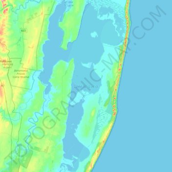
Name: Lake St Lucia topographic map, elevation, terrain.
Average elevation: 20 m
Minimum elevation: -5 m
Maximum elevation: 189 m
Other topographic maps
Click on a map to view its topography, its elevation and its terrain.
Hluhluwe
RSA > KwaZulu-Natal > The Big Five False Bay Local Municipality
Hluhluwe, The Big Five False Bay Local Municipality, Umkhanyakude District Municipality, KwaZulu-Natal, 3936, RSA
Average elevation: 96 m
Makasa Nature Reserve
RSA > KwaZulu-Natal > The Big Five False Bay Local Municipality
Makasa Nature Reserve, D2039, Big Five False Bay Ward 1, The Big Five False Bay Local Municipality, Umkhanyakude District Municipality, KwaZulu-Natal, RSA
Average elevation: 42 m