
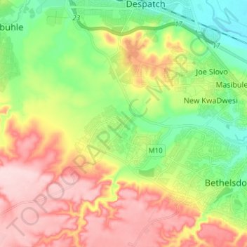
Nelson Mandela Bay Ward 41 topographic map
Interactive map
Click on the map to display elevation.
About this map
Name: Nelson Mandela Bay Ward 41 topographic map, elevation, terrain.
Average elevation: 105 m
Minimum elevation: 4 m
Maximum elevation: 231 m
Other topographic maps
Click on a map to view its topography, its elevation and its terrain.
Nelson Mandela Bay Ward 42
RSA > Eastern Cape > Port Elizabeth
Nelson Mandela Bay Ward 42, Port Elizabeth, Nelson Mandela Bay Metropolitan Municipality, Eastern Cape, RSA
Average elevation: 124 m
Swartkops River
RSA > Eastern Cape > Port Elizabeth
Swartkops River, Port Elizabeth, Nelson Mandela Bay Metropolitan Municipality, Eastern Cape, 6229, RSA
Average elevation: 83 m
Nelson Mandela Bay Ward 1
RSA > Eastern Cape > Port Elizabeth
Nelson Mandela Bay Ward 1, Port Elizabeth, Nelson Mandela Bay Metropolitan Municipality, Eastern Cape, 6070, RSA
Average elevation: 76 m
Jahleel Island
RSA > Eastern Cape > Port Elizabeth
Jahleel Island, Port Elizabeth, Eastern Cape, RSA
Average elevation: 1 m
Brenton Island
RSA > Eastern Cape > Port Elizabeth
Brenton Island, Port Elizabeth, Eastern Cape, RSA
Average elevation: 0 m