
South Darfur State topographic map
Interactive map
Click on the map to display elevation.
About this map
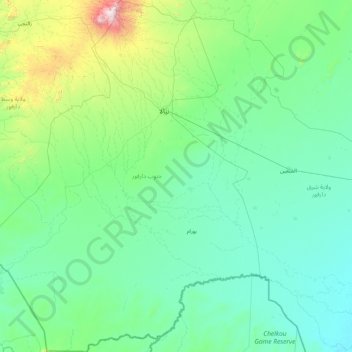
Name: South Darfur State topographic map, elevation, terrain.
Location: South Darfur State, Sudan (9.65536 23.01306 13.13302 25.84902)
Average elevation: 614 m
Minimum elevation: 419 m
Maximum elevation: 2,982 m
Other topographic maps
Click on a map to view its topography, its elevation and its terrain.
Nubian Desert
Sudan > Red Sea State > Halayeb Distrikt
Nubian Desert, Halayeb Distrikt, Red Sea State, Sudan
Average elevation: 602 m
Khartoum
Sudan > Khartoum State > Khartoum
Khartoum, Khartoum State, ١١١١١, Sudan
Average elevation: 388 m