
Lake Assad topographic map
Interactive map
Click on the map to display elevation.
About this map
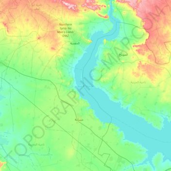
Name: Lake Assad topographic map, elevation, terrain.
Average elevation: 367 m
Minimum elevation: 297 m
Maximum elevation: 608 m
Other topographic maps
Click on a map to view its topography, its elevation and its terrain.
Tal Abu Serra
Syria > Ar-Raqqah Governorate > Khirbat Nahit
Tal Abu Serra, Khirbat Nahit, Ayn Issa Subdistrict, Tell Abyad District, Ar-Raqqah Governorate, Syria
Average elevation: 389 m
Muhafazat Dayr az Zawr
Muhafazat Dayr az Zawr, Al-Mansurah Subdistrict, Al-Thawrah District, Ar-Raqqah Governorate, Syria
Average elevation: 421 m
Hawija
Syria > Ar-Raqqah Governorate > Hawija
Hawija, Ayn Issa Subdistrict, Tell Abyad District, Ar-Raqqah Governorate, Syria
Average elevation: 306 m
Raqqa
Raqqa, Raqqah Subdistrict, Raqqa District, Ar-Raqqah Governorate, Syria
Average elevation: 287 m