
Saint Lawrence topographic map
Interactive map
Click on the map to display elevation.
About this map
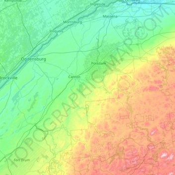
Name: Saint Lawrence topographic map, elevation, terrain.
Location: Saint Lawrence, New York, United States of America (44.05040 -75.86164 45.01586 -74.52526)
Average elevation: 239 m
Minimum elevation: 44 m
Maximum elevation: 929 m
Other topographic maps
Click on a map to view its topography, its elevation and its terrain.
Monsey
United States of America > New York
Monsey, Town of Ramapo, Rockland County, New York, United States of America
Average elevation: 172 m
South Glens Falls
United States of America > New York > South Glens Falls
South Glens Falls, Moreau, Saratoga County, New York, 12803, United States of America
Average elevation: 96 m
Waterburg
United States of America > New York > Waterburg
Waterburg, Ulysses Town, Tompkins County, New York, 14886, United States of America
Average elevation: 318 m
Parish
United States of America > New York > Parish
Parish, Town of Parish, Oswego County, New York, 13131, United States of America
Average elevation: 147 m
Walton Park
United States of America > New York > Walton Park
Walton Park, Town of Monroe, Orange County, New York, United States of America
Average elevation: 216 m
New York County
United States of America > New York > New York
Manhattan, New York County, New York, United States of America
Average elevation: 17 m
Peekskill
United States of America > New York > Peekskill
Peekskill, Westchester, New York, 10566, United States of America
Average elevation: 67 m
Allegany County
United States of America > New York
Allegany County, New York, United States of America
Average elevation: 561 m