
Habersham County topographic map
Interactive map
Click on the map to display elevation.
About this map
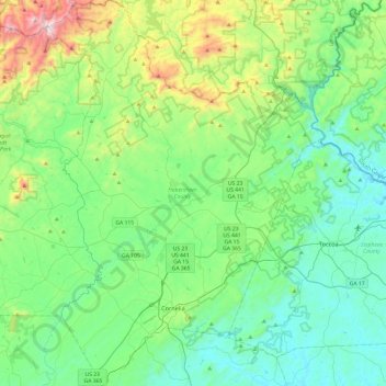
Name: Habersham County topographic map, elevation, terrain.
Location: Habersham County, Georgia, United States of America (34.43119 -83.68168 34.82781 -83.33816)
Average elevation: 448 m
Minimum elevation: 198 m
Maximum elevation: 1,312 m
The highest point in the county is a 4,400-foot (1,300 m) knob less than 700 feet (210 m) southeast of the top of Tray Mountain, the seventh-highest mountain in Georgia. Habersham shares this portion of Tray Mountain, just 30 vertical feet shy of the peak's 4,430-foot summit, with White County to the west and Towns County to the north. 2.4 miles to the northeast of Tray Mountain is Young Lick (elevation 3,809 feet (1,161 m)). The Appalachian Trail runs along the top of the high ridge between Young Lick and Tray, a part of the Blue Ridge Mountain crest.
Other topographic maps
Click on a map to view its topography, its elevation and its terrain.
Bulloch County
United States of America > Georgia
Bulloch County, Georgia, United States of America
Average elevation: 48 m
Baldwin County
United States of America > Georgia
Baldwin County, Georgia, United States of America
Average elevation: 124 m
Whitfield County
United States of America > Georgia
Whitfield County, Georgia, United States of America
Average elevation: 258 m
Augusta
United States of America > Georgia > Augusta
Augusta, Richmond County, Georgia, United States of America
Average elevation: 89 m
Camden County
United States of America > Georgia
Camden County, Georgia, United States of America
Average elevation: 4 m
Worth County
United States of America > Georgia
Worth County, Georgia, United States of America
Average elevation: 95 m
Statesboro
United States of America > Georgia > Statesboro
Statesboro, Bulloch County, Georgia, 30459, United States of America
Average elevation: 66 m
Kingsland
United States of America > Georgia > Kingsland
Kingsland, Camden County, Georgia, 31548, United States of America
Average elevation: 5 m
Murray County
United States of America > Georgia
Murray County, Georgia, United States of America
Average elevation: 381 m
Zebulon
United States of America > Georgia > Zebulon
Zebulon, Pike County, Georgia, United States of America
Average elevation: 254 m
Blue Ridge
United States of America > Georgia > Blue Ridge
Blue Ridge, Fannin County, Georgia, 30513, United States of America
Average elevation: 535 m
Richmond County
United States of America > Georgia
Richmond County, Georgia, United States of America
Average elevation: 96 m
Pickens County
United States of America > Georgia
Pickens County, Georgia, United States of America
Average elevation: 432 m
Tallulah Falls
United States of America > Georgia > Tallulah Falls > Tallulah Falls
Tallulah Falls, Habersham County, Georgia, United States of America
Average elevation: 490 m
Lowndes County
United States of America > Georgia
Lowndes County, Georgia, United States of America
Average elevation: 52 m
Barrow County
United States of America > Georgia
Barrow County, Georgia, United States of America
Average elevation: 261 m