
Eyjafjallajökull topographic map
Interactive map
Click on the map to display elevation.
About this map
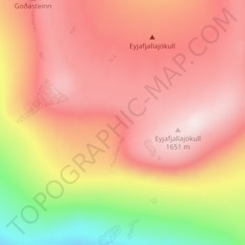
Name: Eyjafjallajökull topographic map, elevation, terrain.
Location: Eyjafjallajökull, Iceland (63.62052 -19.62876 63.62062 -19.62866)
Average elevation: 1,460 m
Minimum elevation: 1,174 m
Maximum elevation: 1,628 m
Other topographic maps
Click on a map to view its topography, its elevation and its terrain.
Þórshöfn
Þórshöfn, Langanesbyggð, Northeastern Region, 680, Iceland
Average elevation: 22 m
Reykjahlíð
Reykjahlíð, Skútustaðahreppur, Northeastern Region, Iceland
Average elevation: 305 m
Þrándarjökull
Þrándarjökull, Djúpavogshreppur, Eastern Region, Iceland
Average elevation: 1,012 m
Tindfjallajökull
Tindfjallajökull, Hungurfitaskáli, Rangárþing ytra, Southern Region, Iceland
Average elevation: 1,059 m