
Tucker County topographic map
Interactive map
Click on the map to display elevation.
About this map
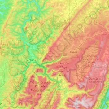
Name: Tucker County topographic map, elevation, terrain.
Location: Tucker County, West Virginia, USA (38.96425 -79.83610 39.27178 -79.29038)
Average elevation: 841 m
Minimum elevation: 389 m
Maximum elevation: 1,451 m
Other topographic maps
Click on a map to view its topography, its elevation and its terrain.
Welch
USA > West Virginia > Welch
Welch, McDowell County, West Virginia, 24801, USA
Average elevation: 548 m
Seneca Rocks
USA > West Virginia > Seneca Rocks
Seneca Rocks, Pendleton County, West Virginia, 26884, USA
Average elevation: 638 m