
Timbavati Game Reserve topographic map
Interactive map
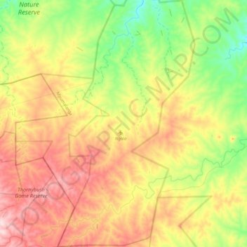
Click on the map to display elevation.
About this map
Name: Timbavati Game Reserve topographic map, elevation, terrain.
Average elevation: 441 m
Minimum elevation: 331 m
Maximum elevation: 582 m
Other topographic maps
Click on a map to view its topography, its elevation and its terrain.
Umbabat Private Game Reserve
RSA > Mpumalanga > Bushbuckridge
Umbabat Private Game Reserve, Birdhide Road, 22 Crossing, Bushbuckridge Ward 34, Bushbuckridge, Ehlanzeni, Mpumalanga, RSA
Average elevation: 345 m
Klaserie Private Nature Reserve
RSA > Mpumalanga > Bushbuckridge
Klaserie Private Nature Reserve, Bushbuckridge Ward 34, Bushbuckridge, Ehlanzeni, Mpumalanga, RSA
Average elevation: 480 m
Manyeleti Game Reserve
RSA > Mpumalanga > Bushbuckridge
Manyeleti Game Reserve, Bushbuckridge Ward 34, Bushbuckridge, Ehlanzeni, Mpumalanga, RSA
Average elevation: 434 m