
Grootspruit topographic map
Interactive map
Click on the map to display elevation.
About this map
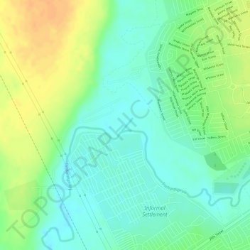
Name: Grootspruit topographic map, elevation, terrain.
Location: Grootspruit, Govan Mbeki, Gert Sibande, Mpumalanga, RSA (-26.55081 29.05750 -26.54935 29.05881)
Average elevation: 1,568 m
Minimum elevation: 1,551 m
Maximum elevation: 1,589 m
Other topographic maps
Click on a map to view its topography, its elevation and its terrain.
Trichardtsfontein Dam
RSA > Mpumalanga > Govan Mbeki
Trichardtsfontein Dam, N17, Govan Mbeki Ward 15, Govan Mbeki, Gert Sibande, Mpumalanga, 2302, RSA
Average elevation: 1,636 m