
Sierra Gorda topographic map
Interactive map
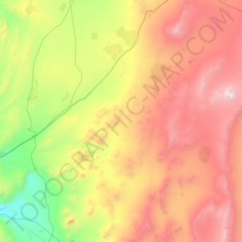
Click on the map to display elevation.
About this map
Name: Sierra Gorda topographic map, elevation, terrain.
Average elevation: 1,988 m
Minimum elevation: 615 m
Maximum elevation: 4,203 m
The region is on a branch of the Sierra Madre Oriental mountain range and consists of a series of mountain chains that run northwest to southeast, formed 240 million years ago. Most are made of limestone, formed by sea beds from the Jurassic and Cretaceous periods. Later there were intrusions of volcanic rock, especially in the eastern portion in Hidalgo state, from which come the mineral deposits of the area. The limestone has been affected by erosion to form the Huasteca Karst, and the area contains a large number of caverns, and pit caves (sótanos), some of which extend for hundreds of meters in depth. All of the Sierra Gorda is marked by very rugged terrain, which includes canyons and steep mountains. Altitudes range from just 300 meters above sea level in the Río Santa María Canyon in Jalpan to 3,100 m asl at the Cerro de la Pingüica in Pinal de Amoles. The most important elevation in the Hidalgo area is the Cerro Cangandhó which has an altitude of 2,820 m asl. Rainfall also varies greatly from 350 mm to 2,000 mm per year. The micro-environments of the region range from conifer forests, oak forests, mostly found on mountain peaks, banana and sugar cane fields in the deeper canyons. On the east side, there are deciduous forests. On the west side, bordering the Mexican Plateau, there are desert and semi desert conditions, with a variety of cacti and arid scrub brush. Among its mountains are the peaks associated with the Sierra Alta de Hidalgo, the pine forests of Zamoarano, the Extoraz Canyon and the slopes of the Huazmazonta, the inter-mountain valleys where the five missions are found and the rolling hills leading into La Huasteca. The wide variations of altitude and rainfall favor a wide variety of flora and wildlife.