
Swartland Ward 3 topographic map
Interactive map
Click on the map to display elevation.
About this map
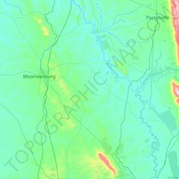
Name: Swartland Ward 3 topographic map, elevation, terrain.
Average elevation: 138 m
Minimum elevation: 17 m
Maximum elevation: 1,199 m
Other topographic maps
Click on a map to view its topography, its elevation and its terrain.
Diep River
RSA > Western Cape > Swartland Local Municipality
Diep River, Swartland Local Municipality, West Coast District Municipality, Western Cape, 7300, RSA
Average elevation: 145 m
Swartland Ward 5
RSA > Western Cape > Swartland Local Municipality
Swartland Ward 5, Swartland Local Municipality, West Coast District Municipality, Western Cape, 7351, RSA
Average elevation: 58 m