
Ushba topographic map
Interactive map
Click on the map to display elevation.
About this map
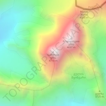
Name: Ushba topographic map, elevation, terrain.
Location: Ushba, Mestia Municipality, Samegrelo-Upper Svaneti, Georgia (43.12395 42.65849 43.12405 42.65859)
Average elevation: 3,640 m
Minimum elevation: 2,941 m
Maximum elevation: 4,687 m
Ushba's south summit is slightly higher than its north summit, which has an elevation of 4,690 m (15,387 ft). The north summit was first climbed in 1888 by John Garford Cokklin and Ulrich Almer, while the south summit saw its first ascent in 1903 by a German-Swiss-Austrian expedition led by B. Rickmer-Rickmers.
Other topographic maps
Click on a map to view its topography, its elevation and its terrain.
2924
Georgia > Samegrelo-Upper Svaneti > Mestia Municipality
2924, Mestia Municipality, Samegrelo-Upper Svaneti, Georgia
Average elevation: 2,627 m
Lekhziri Glacier
Georgia > Samegrelo-Upper Svaneti
Lekhziri Glacier, Mestia Municipality, Samegrelo-Upper Svaneti, Georgia
Average elevation: 3,061 m
Tsaneri Glacier
Georgia > Samegrelo-Upper Svaneti
Tsaneri Glacier, Mestia Municipality, Samegrelo-Upper Svaneti, Georgia
Average elevation: 3,592 m
Tetnuldi
Georgia > Samegrelo-Upper Svaneti
Tetnuldi, Mestia Municipality, Samegrelo-Upper Svaneti, Georgia
Average elevation: 4,016 m
Shkhara
Georgia > Samegrelo-Upper Svaneti
Shkhara, Mestia Municipality, Samegrelo-Upper Svaneti, Georgia
Average elevation: 4,334 m