
Saint Joseph County topographic map
Interactive map
Click on the map to display elevation.
About this map
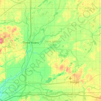
Name: Saint Joseph County topographic map, elevation, terrain.
Location: Saint Joseph County, Michigan, United States of America (41.75905 -85.79185 42.07161 -85.29214)
Average elevation: 262 m
Minimum elevation: 228 m
Maximum elevation: 346 m
Other topographic maps
Click on a map to view its topography, its elevation and its terrain.