
Ramotshere Moiloa Ward 19 topographic map
Interactive map
Click on the map to display elevation.
About this map
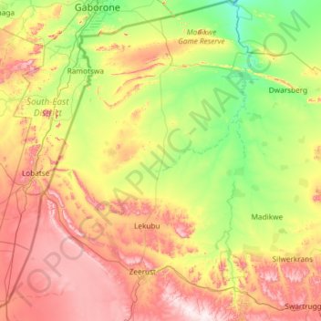
Name: Ramotshere Moiloa Ward 19 topographic map, elevation, terrain.
Average elevation: 1,148 m
Minimum elevation: 916 m
Maximum elevation: 1,566 m
Other topographic maps
Click on a map to view its topography, its elevation and its terrain.
Groot Marico
South Africa > North West > Ramotshere Moiloa Local Municipality
Groot Marico, Ramotshere Moiloa Local Municipality, Ngaka Modiri Molema District Municipality, North West, South Africa
Average elevation: 1,053 m