
Saratoga County topographic map
Interactive map
Click on the map to display elevation.
About this map
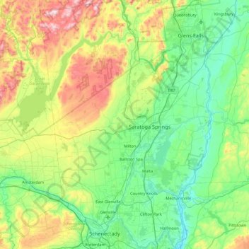
Name: Saratoga County topographic map, elevation, terrain.
Location: Saratoga County, New York, United States (42.77529 -74.16011 43.39770 -73.57332)
Average elevation: 218 m
Minimum elevation: 3 m
Maximum elevation: 833 m
Saratoga County is situated in the eastern portion of New York, north of Albany, northwest of Troy, and east of Utica. According to the U.S. Census Bureau, the county has a total area of 844 square miles (2,190 km2), of which 810 square miles (2,100 km2) are land and 34 square miles (88 km2) (4.0%) are covered by water. The Hudson River forms the eastern border of the county, while the Mohawk River demarcates its southern border. The highest elevation in Saratoga County is at the peak of Tennet Mountain in the Adirondack Mountains, at 2,759 ft (841 m), while the lowest elevation is 69 ft (21 m), at the waterfront of the Village of Waterford, at the confluence of the Mohawk and Hudson Rivers.
Other topographic maps
Click on a map to view its topography, its elevation and its terrain.
Loch Sheldrake
United States > New York > Sullivan County
Loch Sheldrake, Town of Fallsburg, Sullivan County, New York, United States
Average elevation: 448 m
Village of Clayville
United States > New York > Oneida County
Village of Clayville, Town of Paris, Oneida County, New York, United States
Average elevation: 361 m
Rensselaer County
Rensselaer County, New York, United States
Average elevation: 239 m
Ward 6
United States > New York > Cortland County > City of Cortland
Ward 6, City of Cortland, Cortland County, New York, United States
Average elevation: 351 m
Town/Village of East Rochester
United States > New York > Monroe County
Town/Village of East Rochester, Monroe County, New York, 14445, United States
Average elevation: 128 m
Town of Dix
United States > New York > Schuyler County
Town of Dix, Schuyler County, New York, 14891, United States
Average elevation: 331 m
Town of Woodstock
United States > New York > Ulster County
Town of Woodstock, Ulster County, New York, United States
Average elevation: 332 m
Town of Catskill
United States > New York > Greene County
Town of Catskill, Greene County, New York, United States
Average elevation: 59 m
Mount Van Hoevenberg
United States > New York > Essex County > Town of North Elba
Mount Van Hoevenberg, Town of North Elba, Essex County, New York, United States
Average elevation: 677 m
Progress
United States > New York > Fulton County > Progress
Progress, Town of Mayfield, Fulton County, New York, 12078, United States
Average elevation: 264 m
Village of Lake Placid
United States > New York > Essex County > Village of Lake Placid
Village of Lake Placid, Town of North Elba, Essex County, New York, 12946, United States
Average elevation: 558 m
Town of Philipstown
United States > New York > Putnam County
Town of Philipstown, Putnam County, New York, United States
Average elevation: 178 m
Westbury
United States > New York > Nassau County > Westbury > Westbury
Westbury, Town of North Hempstead, Nassau County, New York, 11590, United States
Average elevation: 39 m
Massapequa Park
United States > New York > Nassau County > Massapequa Park
Massapequa Park, Town of Oyster Bay, Nassau County, New York, 11758, United States
Average elevation: 9 m
Town of Pound Ridge
United States > New York > Westchester County > Town of Pound Ridge
Town of Pound Ridge, Westchester County, New York, 10576, United States
Average elevation: 156 m
Lindley Mountain
United States > New York > Orange
Lindley Mountain, Town of Tuxedo, Orange, New York, 10910, United States
Average elevation: 318 m
Westchester County
Westchester County, New York, United States
Average elevation: 95 m
Rockland County
Rockland County, New York, United States
Average elevation: 138 m
City of Rochester
United States > New York > Monroe County > City of Rochester
City of Rochester, Monroe County, New York, United States
Average elevation: 129 m
Village of Black River
United States > New York > Jefferson County
Village of Black River, Town of Le Ray, Jefferson County, New York, United States
Average elevation: 193 m
New York County
United States > New York > New York
New York County, New York, United States
Average elevation: 16 m
City of Saratoga Springs
United States > New York > Saratoga County
City of Saratoga Springs, Saratoga County, New York, 12866, United States
Average elevation: 97 m
Woodstock
United States > New York > Woodstock > Woodstock
Woodstock, Town of Woodstock, Ulster County, New York, 12498, United States
Average elevation: 248 m
Newburgh
United States > New York > Newburgh
Newburgh, Orange, New York, United States
Average elevation: 32 m
Lindley
United States > New York > Steuben County
Lindley, Town of Lindley, Steuben County, New York, 14858, United States
Average elevation: 395 m
Uniondale
United States > New York > Nassau County
Uniondale, Town of Hempstead, Nassau County, New York, United States
Average elevation: 24 m
Chenango County
Chenango County, New York, United States
Average elevation: 442 m
Springs
United States > New York > Suffolk County > Town of East Hampton
Springs, Town of East Hampton, Suffolk County, New York, United States
Average elevation: 6 m
Suffolk County
Suffolk County, New York, United States
Average elevation: 34 m
Still Bay
United States > New York > Warren County > Town of Lake George
Still Bay, Town of Lake George, Warren County, New York, 12845, United States
Average elevation: 153 m
Kings County
United States > New York > New York
Kings County, New York, United States
Average elevation: 9 m