
Bovec topographic map
Interactive map
Click on the map to display elevation.
About this map
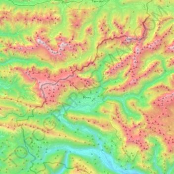
Name: Bovec topographic map, elevation, terrain.
Location: Bovec, Slovenia (46.26599 13.39967 46.44671 13.83655)
Average elevation: 1,151 m
Minimum elevation: 169 m
Maximum elevation: 2,709 m
Bovec is located 136 kilometres (85 mi) from the capital Ljubljana, at an elevation of 434 m (1,424 ft). The settlement lies in the Bovec Basin of the upper Soča (Isonzo) River, below the eastern slopes of Mount Kanin in the Julian Alps, forming the border with Italy. The adjacent Trenta Valley in the northwest leads into Triglav National Park.