
Indus topographic map
Interactive map
Click on the map to display elevation.
About this map
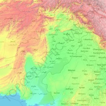
Name: Indus topographic map, elevation, terrain.
Location: Indus, Sindh, 32200, Pakistan (24.01493 67.47054 35.85127 79.71185)
Average elevation: 1,146 m
Minimum elevation: -1 m
Maximum elevation: 7,969 m
Other topographic maps
Click on a map to view its topography, its elevation and its terrain.
Goth Halepoto
Pakistan > Sindh > Matiari District
Goth Halepoto, Matiari Taluka, Matiari District, Hyderabad Division, Sindh, Pakistan
Average elevation: 22 m