
Tisbury topographic map
Interactive map
Click on the map to display elevation.
About this map
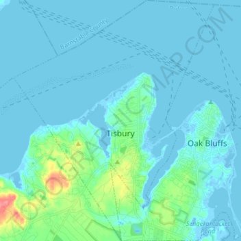
Name: Tisbury topographic map, elevation, terrain.
Location: Tisbury, Dukes County, Massachusetts, 02568, United States (41.41363 -70.67388 41.51181 -70.56482)
Average elevation: 8 m
Minimum elevation: -7 m
Maximum elevation: 70 m
Measuring from the western shore of Tisbury to Nobska Point at Woods Hole (town of Falmouth), the town is 3.3 miles (5.3 km) from the mainland (Cape Cod), the closest point on the Vineyard. Most of central Tisbury is low-lying and near sea level, with elevations rising to 150 feet (46 m) in places. West Chop is the northernmost point on the Vineyard, tipped by the West Chop Light. The town is also home to Lake Tashmoo, just south of the tip of West Chop.