
City of Cape Town topographic map
Interactive map
Click on the map to display elevation.
About this map
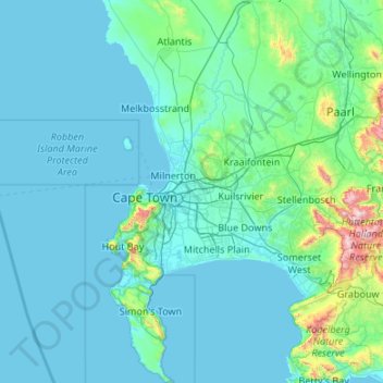
Name: City of Cape Town topographic map, elevation, terrain.
Location: City of Cape Town, Western Cape, South Africa (-34.35834 18.30722 -33.47128 19.00534)
Average elevation: 114 m
Minimum elevation: 0 m
Maximum elevation: 1,586 m
Other topographic maps
Click on a map to view its topography, its elevation and its terrain.
Cape Town
South Africa > Western Cape > City of Cape Town
Cape Town, City of Cape Town, Western Cape, 8001, South Africa
Average elevation: 53 m
Durbanville
South Africa > Western Cape > City of Cape Town
Durbanville, City of Cape Town, Western Cape, 7550, South Africa
Average elevation: 157 m
Khayelitsha
South Africa > Western Cape > City of Cape Town
Khayelitsha, City of Cape Town, Western Cape, 7784, South Africa
Average elevation: 26 m
Table Mountain
South Africa > Western Cape > City of Cape Town > Cape Town
Table Mountain, Cape Town Ward 54, Cape Town, City of Cape Town, Western Cape, 8040, South Africa
Average elevation: 583 m
Paarl
South Africa > Western Cape > Cape Winelands District Municipality
Paarl, Drakenstein Local Municipality, Cape Winelands District Municipality, Western Cape, 7646, South Africa
Average elevation: 358 m
Stellenbosch
South Africa > Western Cape > Cape Winelands District Municipality > Stellenbosch Local Municipality
Stellenbosch, Stellenbosch Local Municipality, Cape Winelands District Municipality, Western Cape, South Africa
Average elevation: 287 m
George
South Africa > Western Cape > Garden Route District Municipality > George Local Municipality
George, George Local Municipality, Garden Route District Municipality, Western Cape, 6530, South Africa
Average elevation: 244 m
Franschhoek
South Africa > Western Cape > Cape Winelands District Municipality > Stellenbosch Local Municipality
Franschhoek, Stellenbosch Local Municipality, Cape Winelands District Municipality, Western Cape, 7690, South Africa
Average elevation: 502 m
Murraysburg
South Africa > Western Cape > Central Karoo District Municipality > Beaufort West Local Municipality
Murraysburg, Beaufort West Local Municipality, Central Karoo District Municipality, Western Cape, 6995, South Africa
Average elevation: 1,219 m
Map of Africa
South Africa > Western Cape > George
Map of Africa, Remskoen, George Ward 4, George Local Municipality, George, Western Cape, 6560, South Africa
Average elevation: 80 m
Darling Wildflower Nature Reserve
South Africa > Western Cape > West Coast District Municipality > Swartland Local Municipality > Darling
Darling Wildflower Nature Reserve, R315, Nuwedorp, Swartland Ward 5, Darling, Swartland Local Municipality, West Coast District Municipality, Western Cape, South Africa
Average elevation: 148 m
Mossel Bay
South Africa > Western Cape > Garden Route District Municipality > Mossel Bay Local Municipality
Mossel Bay, Mossel Bay Local Municipality, Garden Route District Municipality, Western Cape, 6506, South Africa
Average elevation: 16 m
Voëlvlei Lake
South Africa > Western Cape > Cape Winelands District Municipality > Drakenstein Local Municipality
Voëlvlei Lake, Drakenstein Local Municipality, Cape Winelands District Municipality, Western Cape, South Africa
Average elevation: 159 m
Koringberg
South Africa > Western Cape > West Coast District Municipality > Swartland Local Municipality
Koringberg, Swartland Local Municipality, West Coast District Municipality, Western Cape, South Africa
Average elevation: 151 m
Blaauwberg Nature Reserve
South Africa > Western Cape > City of Cape Town > Melkbosstrand
Blaauwberg Nature Reserve, Amble Way, Cape Town Ward 23, Melkbosstrand, City of Cape Town, Western Cape, 7433, South Africa
Average elevation: 46 m
Redelinghuys
South Africa > Western Cape > West Coast District Municipality > Bergrivier Local Municipality
Redelinghuys, Bergrivier Local Municipality, West Coast District Municipality, Western Cape, South Africa
Average elevation: 106 m
Jacobsbaai
South Africa > Western Cape > West Coast District Municipality > Saldanha Bay Local Municipality
Jacobsbaai, Saldanha Bay Local Municipality, West Coast District Municipality, Western Cape, South Africa
Average elevation: 24 m
Jakkalskop
South Africa > Western Cape > Cape Winelands District Municipality > Witzenberg Local Municipality
Jakkalskop, Witzenberg Local Municipality, Cape Winelands District Municipality, Western Cape, South Africa
Average elevation: 375 m
Llandudno Beach
South Africa > Western Cape > City of Cape Town > Cape Town > Llandudno
Llandudno Beach, Llandudno, Cape Town Ward 74, Cape Town, City of Cape Town, Western Cape, South Africa
Average elevation: 108 m
Langvlei
South Africa > Western Cape > West Coast District Municipality > Bergrivier Local Municipality
Langvlei, Bergrivier Ward 1, Bergrivier Local Municipality, West Coast District Municipality, Western Cape, South Africa
Average elevation: 835 m
La Motte
South Africa > Western Cape > Cape Winelands District Municipality > Stellenbosch Local Municipality
La Motte, Stellenbosch Ward 3, Stellenbosch Local Municipality, Cape Winelands District Municipality, Western Cape, South Africa
Average elevation: 315 m
Gansbaai
South Africa > Western Cape > Overstrand Local Municipality
Gansbaai, Overstrand Local Municipality, Western Cape, South Africa
Average elevation: 34 m
De Hoek
South Africa > Western Cape > West Coast District Municipality > Bergrivier Local Municipality
De Hoek, Bergrivier Local Municipality, West Coast District Municipality, Western Cape, 7310, South Africa
Average elevation: 162 m
Plettenberg Bay
South Africa > Western Cape > Garden Route District Municipality > Bitou Local Municipality
Plettenberg Bay, Bitou Local Municipality, Garden Route District Municipality, Western Cape, 6600, South Africa
Average elevation: 47 m
Perdekop
South Africa > Western Cape > Swellendam Local Municipality
Perdekop, Swellendam Local Municipality, Western Cape, South Africa
Average elevation: 424 m
Bredasdorp
South Africa > Western Cape > Overberg District Municipality > Cape Agulhas Local Municipality
Bredasdorp, Cape Agulhas Local Municipality, Overberg District Municipality, Western Cape, 7280, South Africa
Average elevation: 104 m
Cape Town Ward 69
South Africa > Western Cape > City of Cape Town > Noordhoek
Cape Town Ward 69, Noordhoek, City of Cape Town, Western Cape, South Africa
Average elevation: 137 m
Malmesbury
South Africa > Western Cape > West Coast District Municipality > Swartland Local Municipality
Malmesbury, Swartland Local Municipality, West Coast District Municipality, Western Cape, 7300, South Africa
Average elevation: 174 m
Arniston
South Africa > Western Cape > Overberg District Municipality > Cape Agulhas Local Municipality
Arniston, Cape Agulhas Local Municipality, Overberg District Municipality, Western Cape, South Africa
Average elevation: 13 m
Bekbaai
South Africa > Western Cape > West Coast District Municipality > Saldanha Bay Local Municipality > Paternoster
Bekbaai, Saldanha Bay Ward 11, Paternoster, Saldanha Bay Local Municipality, West Coast District Municipality, Western Cape, 7381, South Africa
Average elevation: 21 m
Nduli
South Africa > Western Cape > Cape Winelands District Municipality > Witzenberg Local Municipality
Nduli, Witzenberg Local Municipality, Cape Winelands District Municipality, Western Cape, 6835, South Africa
Average elevation: 503 m
Cape Town Ward 11
South Africa > Western Cape > City of Cape Town > Kuilsrivier
Cape Town Ward 11, Kuilsrivier, City of Cape Town, Western Cape, 7580, South Africa
Average elevation: 58 m
Kurland
South Africa > Western Cape > George
Kurland, George, Western Cape, 6602, South Africa
Average elevation: 226 m
Darling
South Africa > Western Cape > West Coast District Municipality > Swartland Local Municipality
Darling, Swartland Local Municipality, West Coast District Municipality, Western Cape, South Africa
Average elevation: 156 m
Cape Town Ward 98
South Africa > Western Cape > City of Cape Town > Khayelitsha
Cape Town Ward 98, Khayelitsha, City of Cape Town, Western Cape, 7784, South Africa
Average elevation: 27 m
Wolseley
South Africa > Western Cape > Cape Winelands District Municipality > Witzenberg Local Municipality
Wolseley, Witzenberg Local Municipality, Cape Winelands District Municipality, Western Cape, 6830, South Africa
Average elevation: 271 m
Onrus River
South Africa > Western Cape > Overstrand Local Municipality
Onrus River, Overstrand Local Municipality, Western Cape, South Africa
Average elevation: 232 m
Knysna
South Africa > Western Cape > Garden Route District Municipality > Knysna Local Municipality
Knysna, Knysna Local Municipality, Garden Route District Municipality, Western Cape, 6570, South Africa
Average elevation: 95 m
Trafalgar Park
South Africa > Western Cape > City of Cape Town > Cape Town
Trafalgar Park, Cape Town Ward 115, Cape Town, City of Cape Town, Western Cape, 7925, South Africa
Average elevation: 50 m
Malgas
South Africa > Western Cape > Overberg District Municipality > Swellendam Local Municipality
Malgas, Swellendam Ward 3, Swellendam Local Municipality, Overberg District Municipality, Western Cape, South Africa
Average elevation: 47 m
Hout Bay
South Africa > Western Cape > City of Cape Town > Hout Bay
Hout Bay, City of Cape Town, Western Cape, South Africa
Average elevation: 193 m
Hermanus
South Africa > Western Cape > Overstrand Local Municipality
Hermanus, Overstrand Local Municipality, Western Cape, 7200, South Africa
Average elevation: 87 m
Bellville
South Africa > Western Cape > City of Cape Town
Bellville, City of Cape Town, Western Cape, South Africa
Average elevation: 115 m
Herolds Bay
South Africa > Western Cape > George
Herolds Bay, George Ward 23, George Local Municipality, George, Western Cape, South Africa
Average elevation: 105 m
Geelhoutboom
South Africa > Western Cape > George
Geelhoutboom, George Ward 22, George Local Municipality, George, Western Cape, South Africa
Average elevation: 250 m
Botrivier
South Africa > Western Cape > Theewaterskloof Local Municipality
Botrivier, Theewaterskloof Local Municipality, Western Cape, South Africa
Average elevation: 203 m
Reebok
South Africa > Western Cape > George
Reebok, George, Western Cape, 6503, South Africa
Average elevation: 30 m
Saldanha
South Africa > Western Cape > West Coast District Municipality > Saldanha Bay Local Municipality
Saldanha, Saldanha Bay Local Municipality, West Coast District Municipality, Western Cape, 7395, South Africa
Average elevation: 27 m
Prince Albert Road
South Africa > Western Cape > Central Karoo District Municipality > Prince Albert Local Municipality
Prince Albert Road, Prince Albert Ward 1, Prince Albert Local Municipality, Central Karoo District Municipality, Western Cape, South Africa
Average elevation: 622 m
Misty Cliffs
South Africa > Western Cape > City of Cape Town
Misty Cliffs, Cape Town Ward 61, City of Cape Town, Western Cape, South Africa
Average elevation: 135 m