
Pemalang topographic map
Interactive map
Click on the map to display elevation.
About this map
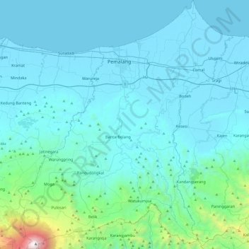
Name: Pemalang topographic map, elevation, terrain.
Location: Pemalang, Central Java, 52361, Indonesia (-7.24889 109.18559 -6.77195 109.59920)
Average elevation: 294 m
Minimum elevation: -1 m
Maximum elevation: 3,408 m
Other topographic maps
Click on a map to view its topography, its elevation and its terrain.
Semarang
Indonesia > Central Java > Semarang > Pleburan
Semarang is located on the northern coast of Java. The city of Semarang is one of the important cities located on the north coast of Java and as the main hub connecting Jakarta and Surabaya, and cities in the southern interior of Java Surakarta and Yogyakarta. Semarang City has a height ranging from 2 m (6.6…
Average elevation: 88 m