
Riebeek East topographic map
Interactive map
Click on the map to display elevation.
About this map
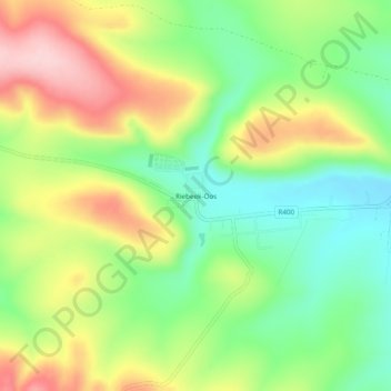
Name: Riebeek East topographic map, elevation, terrain.
Average elevation: 713 m
Minimum elevation: 619 m
Maximum elevation: 838 m
Other topographic maps
Click on a map to view its topography, its elevation and its terrain.
Glen Melville Dam
South Africa > Eastern Cape > Sarah Baartman District Municipality > Makana Local Municipality
Average elevation: 286 m