
County Donegal topographic map
Interactive map
Click on the map to display elevation.
About this map
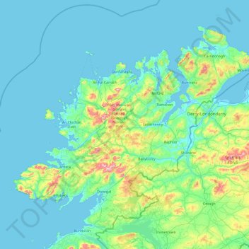
Name: County Donegal topographic map, elevation, terrain.
Location: County Donegal, Ulster, Ireland (54.45905 -8.83471 55.43530 -6.92273)
Average elevation: 74 m
Minimum elevation: -4 m
Maximum elevation: 697 m
The majority of Donegal has a temperate oceanic climate (Köppen climate classification: Cfb), with upland areas in the Derryveagh and Blue Stack ranges classified as oceanic subpolar (Köppen climate classification: Cfc). The county's climate is heavily influenced by the North Atlantic Current. Due to the topography of western Donegal, it receives orographic rainfall, where the air is forced to rise on contact with its mountainous coastline and subsequently cools and condenses, forming clouds. The mountains of Donegal are among the cloudiest places in Ireland, and northern Donegal is the windiest. Irish monthly record wind speeds for March, June, July, September, November and December have all been set at Malin Head. The highest wind speed ever recorded in Donegal was 181 km/h (112 mph) on 16 September 1961, during Hurricane Debbie.
Other topographic maps
Click on a map to view its topography, its elevation and its terrain.
Whiteriver
Whiteriver, Dunleer ED, The Municipal District of Ardee, County Louth, Leinster, Ireland
Average elevation: 117 m
Athlone
Athlone, County Westmeath, Leinster, Ireland
Average elevation: 43 m
Kildare
Kildare, The Municipal District of Kildare — Newbridge, County Kildare, Leinster, Ireland
Average elevation: 103 m
Goatstown
Goatstown, Dún Laoghaire-Rathdown, County Dublin, Leinster, D14 WR83, Ireland
Average elevation: 57 m
Derrymihan
Derrymihan, Killaconenagh, West Cork, County Cork, Munster, P75 WR13, Ireland
Average elevation: 57 m
Inishowen Municipal District
Inishowen Municipal District, County Donegal, Ulster, Ireland
Average elevation: 59 m
Boyne
Boyne, Saint Mary's ED, The Municipal District of Laytown — Bettystown, County Meath, Leinster, A92 NY2V, Ireland
Average elevation: 29 m
Municipal District of Cobh
Municipal District of Cobh, County Cork, Munster, Ireland
Average elevation: 98 m
Moorfield
Moorfield, Morristownbiller ED, The Municipal District of Kildare — Newbridge, County Kildare, Leinster, Ireland
Average elevation: 97 m
Kenmare Municipal District
Kenmare Municipal District, County Kerry, Munster, Ireland
Average elevation: 98 m
Kylemore
Kylemore, Loughrea Municipal District, County Galway, Connacht, Ireland
Average elevation: 45 m
The Municipal District of Cappamore — Kilmallock
The Municipal District of Cappamore — Kilmallock, County Limerick, Munster, Ireland
Average elevation: 107 m
Waterfall
Waterfall, Inishkenny, Municipal District of Carrigaline, County Cork, Munster, T12 CYF2, Ireland
Average elevation: 96 m
Athlone
Ireland > County Westmeath > Athlone
Athlone, The Municipal District of Athlone — Moate, County Westmeath, Leinster, N37 PV34, Ireland
Average elevation: 44 m
Blackrock
Ireland > County Dublin > Blackrock
Blackrock, Dún Laoghaire-Rathdown, County Dublin, Leinster, A94 VP03, Ireland
Average elevation: 30 m
Portmarnock
Ireland > County Dublin > Portmarnock
Portmarnock, Fingal, County Dublin, Leinster, D13 YV05, Ireland
Average elevation: 7 m
Municipal District of Carrigaline
Ireland > County Cork > Municipal District of Carrigaline
Municipal District of Carrigaline, County Cork, Munster, Ireland
Average elevation: 52 m
Grahamstown
Grahamstown, Ballintra ED, Donegal Municipal District, County Donegal, Ireland
Average elevation: 29 m
Simonstown
Simonstown, Navan Rural ED, The Municipal District of Navan, County Meath, Leinster, Ireland
Average elevation: 54 m
Simonstown
Simonstown, Gaybrook, The Municipal District of Mullingar — Kinnegad, County Westmeath, Leinster, Ireland
Average elevation: 112 m
Rathfarnham Village ED
Rathfarnham Village ED, Rathfarnham, South Dublin, County Dublin, Leinster, D6W, Ireland
Average elevation: 55 m
Ballyboggan South
Ballyboggan South, Cabra East A ED, Dublin 11, Dublin, County Dublin, Leinster, Ireland
Average elevation: 41 m
Cherry Orchard
Cherry Orchard, Merchants Quay E ED, Dublin 8, Dublin, County Dublin, Leinster, Ireland
Average elevation: 25 m
Beenkeragh
Beenkeragh, Kenmare Municipal District, County Kerry, Munster, Ireland
Average elevation: 656 m
Lugnaquilla
Lugnaquilla, The Municipal District of Baltinglass, County Wicklow, Leinster, Ireland
Average elevation: 697 m
Renmore
Ireland > Galway City > Galway City
Renmore, Galway City, County Galway, Connacht, Ireland
Average elevation: 6 m
Galway City
Galway, Galway City, County Galway, Connacht, H91 YD86, Ireland
Average elevation: 26 m
Wicklow Mountains National Park
Wicklow Mountains National Park, Mullaghcleevaun to Moanbane and Silsean, Glenbride, Lackan, The Municipal District of Baltinglass, County Wicklow, Leinster, Ireland
Average elevation: 324 m