
County Dublin topographic map
Interactive map
Click on the map to display elevation.
About this map
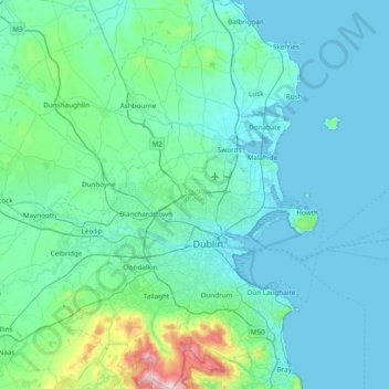
Name: County Dublin topographic map, elevation, terrain.
Location: County Dublin, Leinster, Ireland (53.17826 -6.54689 53.63471 -5.99450)
Average elevation: 71 m
Minimum elevation: -1 m
Maximum elevation: 733 m
Dublin is a topographically varied region. The city centre is generally very low-lying, and many areas of coastal Dublin are at or near sea-level. In the south of the county, the topography rises steeply from sea-level at the coast to over 500 metres (1,600 ft) in just a few kilometres. This natural barrier has resulted in densely populated coastal settlements in Dún Laoghaire–Rathdown and westward urban sprawl in South Dublin. In contrast, Fingal is generally rural in nature and much less densely populated than the rest of the county. Consequently, Fingal is significantly larger than the other three local authorities and covers about 49.5% of County Dublin's land area. Fingal is also perhaps the flattest region in Ireland, with the low-lying Naul Hills rising to a maximum height of just 176 metres (577 ft).
Other topographic maps
Click on a map to view its topography, its elevation and its terrain.
Whiteriver
Whiteriver, Dunleer ED, The Municipal District of Ardee, County Louth, Leinster, Ireland
Average elevation: 117 m
Athlone
Athlone, County Westmeath, Leinster, Ireland
Average elevation: 43 m
Kildare
Kildare, The Municipal District of Kildare — Newbridge, County Kildare, Leinster, Ireland
Average elevation: 103 m
Goatstown
Goatstown, Dún Laoghaire-Rathdown, County Dublin, Leinster, D14 WR83, Ireland
Average elevation: 57 m
Derrymihan
Derrymihan, Killaconenagh, West Cork, County Cork, Munster, P75 WR13, Ireland
Average elevation: 57 m
Inishowen Municipal District
Inishowen Municipal District, County Donegal, Ulster, Ireland
Average elevation: 59 m
Boyne
Boyne, Saint Mary's ED, The Municipal District of Laytown — Bettystown, County Meath, Leinster, A92 NY2V, Ireland
Average elevation: 29 m
Municipal District of Cobh
Municipal District of Cobh, County Cork, Munster, Ireland
Average elevation: 98 m
Moorfield
Moorfield, Morristownbiller ED, The Municipal District of Kildare — Newbridge, County Kildare, Leinster, Ireland
Average elevation: 97 m
Kenmare Municipal District
Kenmare Municipal District, County Kerry, Munster, Ireland
Average elevation: 98 m
Kylemore
Kylemore, Loughrea Municipal District, County Galway, Connacht, Ireland
Average elevation: 45 m
The Municipal District of Cappamore — Kilmallock
The Municipal District of Cappamore — Kilmallock, County Limerick, Munster, Ireland
Average elevation: 107 m
Waterfall
Waterfall, Inishkenny, Municipal District of Carrigaline, County Cork, Munster, T12 CYF2, Ireland
Average elevation: 96 m
Athlone
Ireland > County Westmeath > Athlone
Athlone, The Municipal District of Athlone — Moate, County Westmeath, Leinster, N37 PV34, Ireland
Average elevation: 44 m
Blackrock
Ireland > County Dublin > Blackrock
Blackrock, Dún Laoghaire-Rathdown, County Dublin, Leinster, A94 VP03, Ireland
Average elevation: 30 m
Portmarnock
Ireland > County Dublin > Portmarnock
Portmarnock, Fingal, County Dublin, Leinster, D13 YV05, Ireland
Average elevation: 7 m
Municipal District of Carrigaline
Ireland > County Cork > Municipal District of Carrigaline
Municipal District of Carrigaline, County Cork, Munster, Ireland
Average elevation: 52 m
Grahamstown
Grahamstown, Ballintra ED, Donegal Municipal District, County Donegal, Ireland
Average elevation: 29 m
Simonstown
Simonstown, Navan Rural ED, The Municipal District of Navan, County Meath, Leinster, Ireland
Average elevation: 54 m
Simonstown
Simonstown, Gaybrook, The Municipal District of Mullingar — Kinnegad, County Westmeath, Leinster, Ireland
Average elevation: 112 m
Rathfarnham Village ED
Rathfarnham Village ED, Rathfarnham, South Dublin, County Dublin, Leinster, D6W, Ireland
Average elevation: 55 m
Ballyboggan South
Ballyboggan South, Cabra East A ED, Dublin 11, Dublin, County Dublin, Leinster, Ireland
Average elevation: 41 m
Cherry Orchard
Cherry Orchard, Merchants Quay E ED, Dublin 8, Dublin, County Dublin, Leinster, Ireland
Average elevation: 25 m
Beenkeragh
Beenkeragh, Kenmare Municipal District, County Kerry, Munster, Ireland
Average elevation: 656 m
Lugnaquilla
Lugnaquilla, The Municipal District of Baltinglass, County Wicklow, Leinster, Ireland
Average elevation: 697 m
Renmore
Ireland > Galway City > Galway City
Renmore, Galway City, County Galway, Connacht, Ireland
Average elevation: 6 m
Galway City
Galway, Galway City, County Galway, Connacht, H91 YD86, Ireland
Average elevation: 26 m
Wicklow Mountains National Park
Wicklow Mountains National Park, Mullaghcleevaun to Moanbane and Silsean, Glenbride, Lackan, The Municipal District of Baltinglass, County Wicklow, Leinster, Ireland
Average elevation: 324 m