
Biscay topographic map
Interactive map
Click on the map to display elevation.
About this map
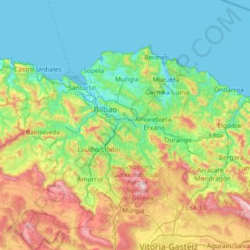
Name: Biscay topographic map, elevation, terrain.
Location: Biscay, Basque Country, Spain (42.96872 -3.45035 43.45686 -2.41272)
Average elevation: 333 m
Minimum elevation: -2 m
Maximum elevation: 1,478 m
Other topographic maps
Click on a map to view its topography, its elevation and its terrain.
Oribi
Spain > Basque Country > Legazpi
Oribi, Legazpi, Goierri, Gipuzkoa, Basque Country, 20220, Spain
Average elevation: 662 m
La Dehesa
Spain > Basque Country > Orduña-Urduña
La Dehesa, Orduña-Urduña, Arratia-Nerbioi, Biscay, Basque Country, 48460, Spain
Average elevation: 375 m