
Kamberg Nature Reserve topographic map
Interactive map
Click on the map to display elevation.
About this map
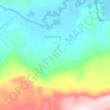
Name: Kamberg Nature Reserve topographic map, elevation, terrain.
Average elevation: 1,857 m
Minimum elevation: 1,678 m
Maximum elevation: 2,240 m
Other topographic maps
Click on a map to view its topography, its elevation and its terrain.
Mpofana Ward 4
RSA > KwaZulu-Natal > Mpofana Local Municipality
Mpofana Ward 4, Mpofana Local Municipality, uMgungundlovu District Municipality, KwaZulu-Natal, RSA
Average elevation: 1,282 m