
Slope County topographic map
Interactive map
Click on the map to display elevation.
About this map
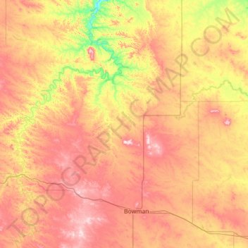
Name: Slope County topographic map, elevation, terrain.
Location: Slope County, North Dakota, United States (46.27931 -104.04610 46.63102 -102.92453)
Average elevation: 860 m
Minimum elevation: 700 m
Maximum elevation: 1,049 m
White Butte, the highest natural point in North Dakota at an elevation of 3506 ft (1062 m), is in southeast Slope County.
Other topographic maps
Click on a map to view its topography, its elevation and its terrain.
Mayville
United States > North Dakota > Traill County
Mayville, Traill County, North Dakota, 58257, United States
Average elevation: 296 m
Carrington
United States > North Dakota > Foster County
Carrington, Foster County, North Dakota, 58421, United States
Average elevation: 484 m
Oberon
United States > North Dakota > Benson County
Oberon, Benson County, North Dakota, United States
Average elevation: 474 m
McKenzie County
McKenzie County, North Dakota, United States
Average elevation: 681 m
Oliver County
Oliver County, North Dakota, United States
Average elevation: 610 m
Mountain
United States > North Dakota > Pembina County
Mountain, Pembina County, North Dakota, United States
Average elevation: 325 m
Jamestown
United States > North Dakota > Jamestown
Jamestown, Stutsman County, North Dakota, United States
Average elevation: 451 m
Ward County
Ward County, North Dakota, United States
Average elevation: 579 m
Bowman County
Bowman County, North Dakota, United States
Average elevation: 899 m
Williston
United States > North Dakota > Williams County
Williston, Williams County, North Dakota, United States
Average elevation: 603 m