
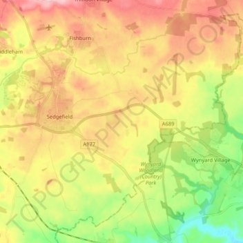
Sedgefield topographic map
Interactive map
Click on the map to display elevation.
About this map
Name: Sedgefield topographic map, elevation, terrain.
Average elevation: 86 m
Minimum elevation: 9 m
Maximum elevation: 162 m
Other topographic maps
Click on a map to view its topography, its elevation and its terrain.
Auckland Park
United Kingdom > England > County Durham > Coundon Grange
Auckland Park, Dene Valley, Coundon Grange, County Durham, North East, England, DL14 8YW, United Kingdom
Average elevation: 126 m
Peterlee
United Kingdom > England > County Durham > Peterlee
Peterlee, County Durham, North East England, England, United Kingdom
Average elevation: 92 m
Durham
United Kingdom > England > County Durham
Durham, County Durham, North East, England, DH1 3NG, United Kingdom
Average elevation: 119 m