
Nagarjuna Sagar-Srisailam Tiger Reserve topographic map
Interactive map
Click on the map to display elevation.
About this map
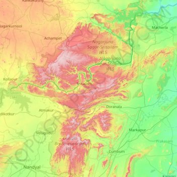
Name: Nagarjuna Sagar-Srisailam Tiger Reserve topographic map, elevation, terrain.
Location: Nagarjuna Sagar-Srisailam Tiger Reserve, Andhra Pradesh, India (15.39922 78.55019 16.67040 79.31271)
Average elevation: 340 m
Minimum elevation: 51 m
Maximum elevation: 956 m
Other topographic maps
Click on a map to view its topography, its elevation and its terrain.
Vijayawada
Vijayawada lies on the banks of Krishna river, covered by hills and canals. and at an altitude of 11 m (36 ft) above sea level. Three canals originating from the north side of the Prakasam Barrage reservoir — Eluru, Bandar, and Ryves — flow through the city.
Average elevation: 37 m
Madakasira
India > Andhra Pradesh > Madakasira
Madakasira is located at 13°56′13″N 77°16′10″E / 13.9369°N 77.2694°E / 13.9369; 77.2694. It has an average elevation of 676 metres (2221 ft). The height of the Madakasira hill is 2936 feet from the Sea Level.Formerly Madakasira is called as SIMHAGIRI because hill from one side looks like a…
Average elevation: 684 m
Ongole
India > Andhra Pradesh > Ongole
Ongole is located at 15.5°N 80.05°E. It has an average elevation of 10 m (33 ft) AMSL and is situated on the plains. The city is around 149 kilometres (93 mi) to the south west of Amaravati, the stat capital.
Average elevation: 15 m
Jammalamadugu
India > Andhra Pradesh > Jammalamadugu
Jammalamadugu is at 14°50′N 78°24′E / 14.83°N 78.4°E / 14.83; 78.4. It has an average elevation of 169 metres (554 feet).
Average elevation: 184 m
Visakhapatnam
India > Andhra Pradesh > Visakhapatnam (Urban)
The city is situated between the Eastern Ghats and the Bay of Bengal. The city coordinates lies between 17.7041 N and 83.2977 E. The city's area is 682 km2. The average elevation is 45 metres. Visakhpatnam is situated in Coastal Andhra Region.
Average elevation: 35 m
Madanapalle
India > Andhra Pradesh > Madanapalle
It is located at an average elevation of 695 m (2,280 ft) above mean sea level.
Average elevation: 766 m
Gooty
India > Andhra Pradesh > Gooty
Gooty is located at 15°07′N 77°38′E / 15.12°N 77.63°E / 15.12; 77.63, at a distance of 52 km from Anantapur. It has an average elevation of 345 metres (1131 feet).
Average elevation: 364 m
Palakollu
India > Andhra Pradesh > Palacole
At an average altitude of 1.5 metres (4.9 ft), Palakollu town is situated on National Highway 165 (India) and National Highway 216 (India). It is bounded by Krishna district and Vijayawada on the west, Amalapuram and Bay of Bengal on the east, Narasapuram and Bay of Bengal on the south, and Rajahmundry and…
Average elevation: 7 m
Visakhapatnam
India > Andhra Pradesh > Visakhapatnam (Urban)
The city is situated between the Eastern Ghats and the Bay of Bengal. The city coordinates lies between 17.7041 N and 83.2977 E. The city's area is 682 km2. The average elevation is 45 metres. Visakhpatnam is situated in Coastal Andhra Region.
Average elevation: 35 m
Madanapalle
India > Andhra Pradesh > Madanapalle
It is located at an average elevation of 695 m (2,280 ft) above mean sea level.
Average elevation: 766 m
Narsipatnam
India > Andhra Pradesh > Narsipatnam
Narsipatnam is located at 17°40′N 82°37′E / 17.67°N 82.62°E / 17.67; 82.62. It has an average elevation of 58 metres (190 feet). This is one of the five places in India where the IST line passes
Average elevation: 88 m
Anakapalle
India > Andhra Pradesh > Anakapalle
Anakapalli is located at 17°41′29″N 83°00′14″E / 17.6913°N 83.0039°E / 17.6913; 83.0039, on the banks of River Sarada and at an altitude of 29 m (95 ft). It is spread over an area of 23.28 km2 (8.99 sq mi).
Average elevation: 35 m
Siddavatam
India > Andhra Pradesh > Sidhout
Siddhavattam is located at 14°28′00″N 78°58′11″E / 14.4667°N 78.9698°E / 14.4667; 78.9698. It has an average elevation of 111 meters (354 feet). It is located on the left bank of river Penna on the route to Badvel from Kadapa at a distance of about 25 km.
Average elevation: 169 m
Madakasira
India > Andhra Pradesh > Madakasira
Madakasira is located at 13°56′13″N 77°16′10″E / 13.9369°N 77.2694°E / 13.9369; 77.2694. It has an average elevation of 676 metres (2221 ft). The height of the Madakasira hill is 2936 feet from the Sea Level.Formerly Madakasira is called as SIMHAGIRI because hill from one side looks like a…
Average elevation: 684 m
East Godavari
East Godavari occupies an area of 12,805 square kilometres (4,944 sq mi), comparatively equivalent to Indonesia's Sumba Island. The district is bounded on north by Visakhapatnam district, Malkangiri district of Orissa on the northwest by Khammam district and Sukma district of Chhattisgarh, on the east and…
Average elevation: 60 m
Mylavaram
India > Andhra Pradesh > Mylavaram
Mylavaram is located at 16°47′00″N 80°38′00″E / 16.7833°N 80.6333°E / 16.7833; 80.6333. It has an average elevation of 47 metres (157 feet).
Average elevation: 59 m