
Kunene Region topographic map
Interactive map
Click on the map to display elevation.
About this map
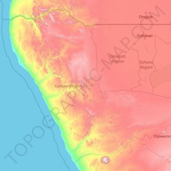
Name: Kunene Region topographic map, elevation, terrain.
Location: Kunene Region, Namibia (-21.19346 11.73689 -16.96349 16.72248)
Average elevation: 772 m
Minimum elevation: -2 m
Maximum elevation: 2,398 m
Other topographic maps
Click on a map to view its topography, its elevation and its terrain.