
Strasbourg topographic map
Interactive map
Click on the map to display elevation.
About this map
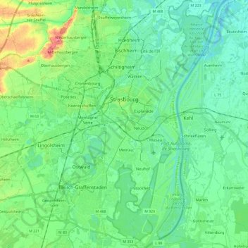
Name: Strasbourg topographic map, elevation, terrain.
Location: Strasbourg, Bas-Rhin, Grand Est, Metropolitan France, France (48.49186 7.68814 48.64619 7.83606)
Average elevation: 144 m
Minimum elevation: 127 m
Maximum elevation: 193 m
Other topographic maps
Click on a map to view its topography, its elevation and its terrain.
Saint-Pierre
Saint-Pierre, Sélestat-Erstein, Bas-Rhin, Grand Est, Metropolitan France, 67140, France
Average elevation: 184 m