
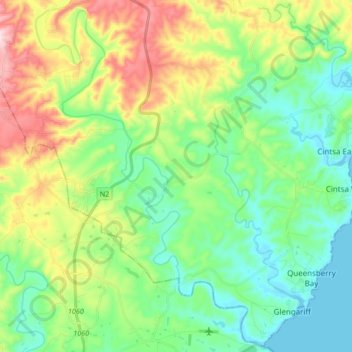
Great Kei Ward 1 topographic map
Interactive map
Click on the map to display elevation.
About this map
Name: Great Kei Ward 1 topographic map, elevation, terrain.
Average elevation: 118 m
Minimum elevation: -1 m
Maximum elevation: 376 m
Other topographic maps
Click on a map to view its topography, its elevation and its terrain.
Great Kei Ward 6
RSA > Eastern Cape > Great Kei Local Municipality
Great Kei Ward 6, Great Kei Local Municipality, Amathole District Municipality, Eastern Cape, RSA
Average elevation: 132 m
Kwenxura
RSA > Eastern Cape > Great Kei Local Municipality
Kwenxura, Great Kei Local Municipality, Amathole District Municipality, Eastern Cape, 5275, RSA
Average elevation: 236 m