
Constanța topographic map
Interactive map
Click on the map to display elevation.
About this map
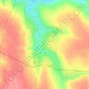
Name: Constanța topographic map, elevation, terrain.
Location: Pietreni, Constanța, 907112, Romania (44.09063 28.06185 44.10550 28.07533)
Average elevation: 121 m
Minimum elevation: 69 m
Maximum elevation: 152 m
Other topographic maps
Click on a map to view its topography, its elevation and its terrain.
Târgu Mureș
Târgu Mureș, Targu Mures Metropolitan Area, Mureș, Romania
Average elevation: 357 m
Lac de Acumulare Sântămăria-Orlea
Lac de Acumulare Sântămăria-Orlea, Nălațvad, Hateg, Hunedoara, 335501, Romania
Average elevation: 328 m
Sălașu de Sus
Sălașu de Sus, Hunedoara, 337420, Romania
Average elevation: 491 m
Danube Delta Biosphere Reserve
Danube Delta Biosphere Reserve, Tulcea, 827051, Romania
Average elevation: 3 m
Retezat National Park
Retezat National Park, Hunedoara, Romania
Average elevation: 1,443 m