
Kars merkez topographic map
Interactive map
Click on the map to display elevation.
About this map
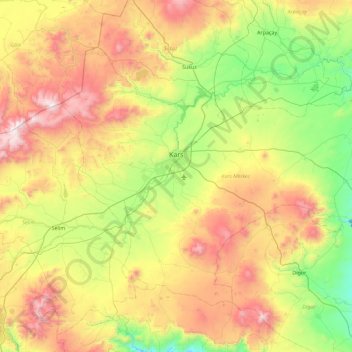
Name: Kars merkez topographic map, elevation, terrain.
Location: Kars merkez, Kars, Eastern Anatolia Region, Turkey (40.31158 42.80017 40.81807 43.70010)
Average elevation: 1,894 m
Minimum elevation: 1,237 m
Maximum elevation: 2,949 m
Other topographic maps
Click on a map to view its topography, its elevation and its terrain.
Muş merkez
Turkey > Eastern Anatolia Region
Muş merkez, Muş, Eastern Anatolia Region, Turkey
Average elevation: 1,650 m
Muş
Turkey > Eastern Anatolia Region > Muş
Muş, Muş merkez, Muş, Eastern Anatolia Region, 49001, Turkey
Average elevation: 1,590 m