
Bourg-Saint-Pierre topographic map
Interactive map
Click on the map to display elevation.
About this map
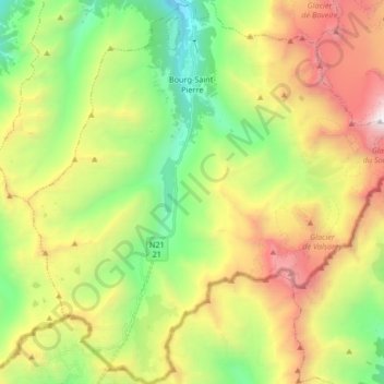
Name: Bourg-Saint-Pierre topographic map, elevation, terrain.
Location: Bourg-Saint-Pierre, Entremont, Valais/Wallis, 1946, Switzerland (45.85868 7.13761 45.97421 7.30085)
Average elevation: 2,530 m
Minimum elevation: 1,442 m
Maximum elevation: 4,151 m