
Wausau topographic map
Interactive map
Click on the map to display elevation.
About this map
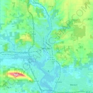
Name: Wausau topographic map, elevation, terrain.
Location: Wausau, Marathon County, Wisconsin, United States (44.91855 -89.76793 45.00644 -89.57292)
Average elevation: 394 m
Minimum elevation: 351 m
Maximum elevation: 585 m
According to the United States Census Bureau, the city has a total area of 20.33 square miles (52.7 km2), of which 19.22 square miles (49.8 km2) is land and 1.11 square miles (2.9 km2) is water. The city is located at an altitude of 1,195 feet (364 m). Wausau is close to the center of the northern half of the Western Hemisphere. Just west of Wausau, 45°N meets 90°W (45°N 90°W / 45°N 90°W / 45; -90), which is exactly halfway between the equator and the north pole and a quarter of the way around the world from the prime meridian.
Other topographic maps
Click on a map to view its topography, its elevation and its terrain.
Abbotsford
United States > Wisconsin > Marathon County
Abbotsford, Marathon County, Wisconsin, 54405, United States
Average elevation: 427 m
Rothschild
United States > Wisconsin > Marathon County
Rothschild, Marathon County, Wisconsin, 54474, United States
Average elevation: 367 m
Spencer
United States > Wisconsin > Marathon County
Spencer, Marathon County, Wisconsin, 54479, United States
Average elevation: 398 m
Rib Falls
United States > Wisconsin > Marathon County
Rib Falls, Town of Rib Falls, Marathon County, Wisconsin, 77996, United States
Average elevation: 394 m
Marathon City
United States > Wisconsin > Marathon County
Marathon City, Marathon County, Wisconsin, 54448, United States
Average elevation: 389 m
Town of Stettin
United States > Wisconsin > Marathon County
Town of Stettin, Marathon County, Wisconsin, 54401, United States
Average elevation: 398 m
Stack Island
United States > Wisconsin > Marathon County > Wausau
Stack Island, Wausau, Marathon County, Wisconsin, 54401, United States
Average elevation: 401 m
Hatley
United States > Wisconsin > Marathon County
Hatley, Marathon County, Wisconsin, United States
Average elevation: 393 m
Ringle
United States > Wisconsin > Marathon County
Ringle, Marathon County, Wisconsin, 54471, United States
Average elevation: 401 m
Village of Weston
United States > Wisconsin > Marathon County
Village of Weston, Marathon County, Wisconsin, 54476, United States
Average elevation: 371 m
Rib Mountain
United States > Wisconsin > Marathon County
Rib Mountain, Town of Rib Mountain, Marathon County, Wisconsin, United States
Average elevation: 380 m
Athens
United States > Wisconsin > Marathon County
Athens, Marathon County, Wisconsin, United States
Average elevation: 420 m
Town of Berlin
United States > Wisconsin > Marathon County
Town of Berlin, Marathon County, Wisconsin, United States
Average elevation: 421 m
Rozellville
United States > Wisconsin > Marathon County
Rozellville, Town of Day, Marathon County, Wisconsin, United States
Average elevation: 378 m
Stratford
United States > Wisconsin > Marathon County
Stratford, Marathon County, Wisconsin, 54484, United States
Average elevation: 382 m
Town of Brighton
United States > Wisconsin > Marathon County
Town of Brighton, Marathon County, Wisconsin, United States
Average elevation: 403 m
Kronenwetter
United States > Wisconsin > Marathon County
Kronenwetter, Marathon County, Wisconsin, 13245, United States
Average elevation: 373 m
Mosinee
United States > Wisconsin > Marathon County
Mosinee, Marathon County, Wisconsin, 54455, United States
Average elevation: 357 m