
South Pyongan topographic map
Interactive map
Click on the map to display elevation.
About this map
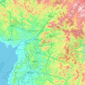
Name: South Pyongan topographic map, elevation, terrain.
Location: South Pyongan, North Korea (38.91167 124.91837 40.34960 127.17848)
Average elevation: 390 m
Minimum elevation: -1 m
Maximum elevation: 2,146 m
Other topographic maps
Click on a map to view its topography, its elevation and its terrain.
Paektu Mountain
Paektu Mountain, Samjiyon County, Ryanggang, North Korea
Average elevation: 2,207 m