
Sarajevo Canton topographic map
Interactive map
Click on the map to display elevation.
About this map
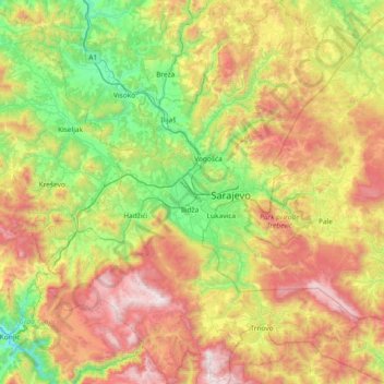
Name: Sarajevo Canton topographic map, elevation, terrain.
Location: Sarajevo Canton, B&H (43.58693 18.00096 44.12066 18.62962)
Average elevation: 957 m
Minimum elevation: 274 m
Maximum elevation: 2,065 m
Other topographic maps
Click on a map to view its topography, its elevation and its terrain.
Župica
B&H > Entity Federation of Bosnia and Herzegovina > Župica
Župica, Drvar municipality, Canton 10, Entity Federation of Bosnia and Herzegovina, B&H
Average elevation: 676 m
Galičica
B&H > Entity Federation of Bosnia and Herzegovina > Galičica
Galičica, Gornji Vakuf/Uskoplje municipality, Central Bosnia Canton, Entity Federation of Bosnia and Herzegovina, 70240, B&H
Average elevation: 796 m
Čvrsnica
B&H > Entity Federation of Bosnia and Herzegovina > Turističko naselje Risovac
Čvrsnica, Put munike, Zelenike, Naselje Risovac, Turističko naselje Risovac, Jablanica municipality, Herzegovina-Neretva Canton, Entity Federation of Bosnia and Herzegovina, B&H
Average elevation: 1,359 m
Mostar
B&H > Entity Federation of Bosnia and Herzegovina > Mostar
Mostar, City of Mostar, Herzegovina-Neretva Canton, Entity Federation of Bosnia and Herzegovina, 88000, B&H
Average elevation: 591 m
Vučipolje
B&H > Federation of Bosnia and Herzegovina > Vučipolje
Vučipolje, Bugojno Municipality, Central Bosnia Canton, Federation of Bosnia and Herzegovina, 70230, B&H
Average elevation: 602 m