
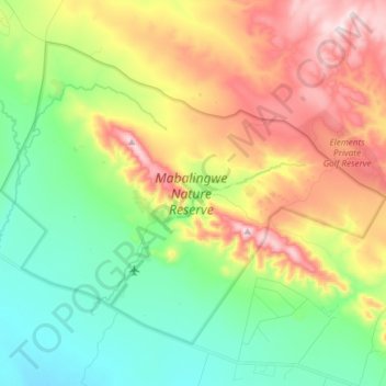
Mabalingwe Nature Reserve topographic map
Interactive map
Click on the map to display elevation.
About this map
Name: Mabalingwe Nature Reserve topographic map, elevation, terrain.
Average elevation: 1,292 m
Minimum elevation: 1,106 m
Maximum elevation: 1,584 m
Other topographic maps
Click on a map to view its topography, its elevation and its terrain.
Rust de Winter Dam
RSA > Limpopo > Bela Bela Local Municipality
Rust de Winter Dam, Bela-Bela Ward 8, Bela Bela Local Municipality, Limpopo, RSA
Average elevation: 1,061 m