
Makuleke topographic map
Interactive map
Click on the map to display elevation.
About this map
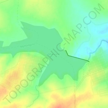
Name: Makuleke topographic map, elevation, terrain.
Average elevation: 417 m
Minimum elevation: 398 m
Maximum elevation: 441 m
Other topographic maps
Click on a map to view its topography, its elevation and its terrain.
Mutshindudi
RSA > Limpopo > Thulamela Local Municipality
Mutshindudi, Thulamela Local Municipality, Limpopo, RSA
Average elevation: 495 m
Vondo Dam
RSA > Limpopo > Thulamela Local Municipality
Vondo Dam, Thulamela Local Municipality, Limpopo, RSA
Average elevation: 908 m
Luvuvhu
RSA > Limpopo > Thulamela Local Municipality
Luvuvhu, Thulamela Local Municipality, Limpopo, RSA
Average elevation: 511 m
Mphongolo
RSA > Limpopo > Thulamela Local Municipality
Mphongolo, Thulamela Local Municipality, Limpopo, RSA
Average elevation: 419 m