
Uttar Pradesh topographic map
Interactive map
Click on the map to display elevation.
About this map
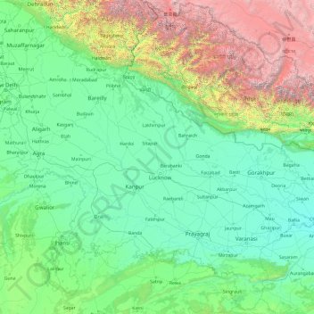
Name: Uttar Pradesh topographic map, elevation, terrain.
Location: Uttar Pradesh, India (23.87063 77.08388 30.40638 84.63451)
Average elevation: 954 m
Minimum elevation: 47 m
Maximum elevation: 7,878 m
Uttar Pradesh, with a total area of 243,290 square kilometres (93,935 sq mi), is India's fourth-largest state in terms of land area and is roughly of same size as United Kingdom. It is situated on the northern spout of India and shares an international boundary with Nepal. The Himalayas border the state on the north, but the plains that cover most of the state are distinctly different from those high mountains. The larger Gangetic Plain region is in the north; it includes the Ganges-Yamuna Doab, the Ghaghra plains, the Ganges plains and the Terai. The smaller Vindhya Range and plateau region are in the south. It is characterised by hard rock strata and a varied topography of hills, plains, valleys and plateaus. The Bhabhar tract gives place to the terai area which is covered with tall elephant grass and thick forests interspersed with marshes and swamps. The sluggish rivers of the bhabhar deepen in this area, their course running through a tangled mass of thick undergrowth. The terai runs parallel to the bhabhar in a thin strip. The entire alluvial plain is divided into three sub-regions. The first in the eastern tract consisting of 14 districts which are subject to periodical floods and droughts and have been classified as scarcity areas. These districts have the highest density of population which gives the lowest per capita land. The other two regions, the central and the western, are comparatively better with a well-developed irrigation system. They suffer from waterlogging and large-scale user tracts. In addition, the area is fairly arid. The state has more than 32 large and small rivers; of them, the Ganga, Yamuna, Saraswati, Sarayu, Betwa, and Ghaghara are larger and of religious importance in Hinduism.
Other topographic maps
Click on a map to view its topography, its elevation and its terrain.
Kanpur Dehat District
Kanpur Dehat District, Uttar Pradesh, India
Average elevation: 132 m
Bengaluru
India > Karnataka > Bangalore North
Bengaluru, Bangalore North, Bengaluru Urban, Karnataka, India
Average elevation: 886 m
Car Nicobar
India > Andaman and Nicobar Islands
Car Nicobar, Nicobar District, Andaman and Nicobar Islands, India
Average elevation: 11 m
Coronation Park
India > Delhi > Model Town Tehsil
Coronation Park, Model Town Tehsil, North Delhi District, Delhi, India
Average elevation: 209 m
Bangalore South
Bangalore South, Bengaluru Urban, Karnataka, India
Average elevation: 847 m
Eastern West Khasi Hills District
Eastern West Khasi Hills District, Meghalaya, 793120, India
Average elevation: 1,176 m
Amber
India > Rajasthan > Amber Tehsil > Jaipur Municipal Corporation
Amber, Jaipur Municipal Corporation, Amber Tehsil, Jaipur District, Rajasthan, 303101, India
Average elevation: 468 m
Ankleshwar
India > Gujarat > Ankleshwar Taluka
Ankleshwar, Ankleshwar Taluka, Bharuch District, Gujarat, India
Average elevation: 17 m
Sundargarh
India > Odisha > Sundargarh Town
Sundargarh, Sundargarh Town, Sundargarh District, Odisha, 770001, India
Average elevation: 243 m
Khasi Hills
India > Meghalaya > Mawshynrut
Khasi Hills, Mawshynrut, West Khasi Hills District, Meghalaya, India
Average elevation: 349 m
Sullurpeta
India > Andhra Pradesh > Sullurpeta
Sullurpeta, Tirupati District, Andhra Pradesh, 524121, India
Average elevation: 4 m
Vinchhiya
India > Gujarat > Vinchhiya Taluka
Vinchhiya, Vinchhiya Taluka, Rajkot District, Gujarat, 360050, India
Average elevation: 173 m
South Lhonak Glacier
India > Sikkim > Chungthang
South Lhonak Glacier, Chungthang, Mangan District, Sikkim, India
Average elevation: 5,830 m
New Town
New Town, North 24 Parganas District, West Bengal, 700161, India
Average elevation: 5 m
Khutala
India > Maharashtra > Chimur Taluka
Khutala, Chimur Taluka, Chandrapur District, Maharashtra, 442904, India
Average elevation: 225 m
Ward 91
India > Tamil Nadu > Ambattur
Ward 91, Zone 7 Ambattur, Ambattur, Thiruvallur District, Tamil Nadu, 600037, India
Average elevation: 15 m
Nicobar Islands
India > Andaman and Nicobar Islands > Great Nicobar
Nicobar Islands, Great Nicobar, Nicobar, Andaman and Nicobar Islands, India
Average elevation: 2 m
Pallavaram
Pallavaram, Chengalpattu District, Tamil Nadu, India
Average elevation: 21 m
Dantiwada
India > Gujarat > Dantiwada Taluka
Dantiwada, Dantiwada Taluka, Banas Kantha District, Gujarat, 385505, India
Average elevation: 168 m
Sriperumbudur
Sriperumbudur, Kanchipuram District, Tamil Nadu, India
Average elevation: 48 m
Ward 92
India > Tamil Nadu > Ambattur
Ward 92, Zone 7 Ambattur, Ambattur, Thiruvallur District, Tamil Nadu, India
Average elevation: 15 m
Hassan
India > Karnataka > Hasana taluk
Hassan, Hasana taluk, Hassan district, Karnataka, 573201, India
Average elevation: 949 m
Leh
India > Ladakh > Leh Tehsil
Leh, Leh Tehsil, Leh district, Ladakh, India
Average elevation: 3,653 m
Bengaluru
India > Karnataka > Bangalore North > Bengaluru
Bengaluru, Bangalore North, Bangalore Urban, Karnataka, 560001, India
Average elevation: 879 m
Vasana
India > Karnataka > Harihara taluku > Vasana
Vasana, Harihara taluku, Davanagere District, Karnataka, 581119, India
Average elevation: 543 m
Ward 37
India > Odisha > Bhubaneswar (M.Corp.) > Bhubaneswar Municipal Corporation
Ward 37, South West Zone, Bhubaneswar Municipal Corporation, Bhubaneswar (M.Corp.), Khordha, Odisha, 751001, India
Average elevation: 51 m
Marina Beach
India > Tamil Nadu > Chennai
Marina Beach, Ward 116, Zone 9, Chennai, Chennai District, Tamil Nadu, 600001, India
Average elevation: 4 m
Company Garden
India > Rajasthan > Alwar Tehsil > Alwar
Company Garden, Alwar, Alwar Tehsil, Alwar, Rajasthan, India
Average elevation: 277 m
Ward 29
India > Tamil Nadu > Chennai
Ward 29, Zone 3 Madhavaram, Chennai, Mathavaram, Thiruvallur District, Tamil Nadu, India
Average elevation: 6 m
Hyderabad
India > Telangana > Bahadurpura mandal
Hyderabad, Bahadurpura mandal, Hyderabad District, Telangana, India
Average elevation: 549 m