
Armavir topographic map
Interactive map
Click on the map to display elevation.
About this map
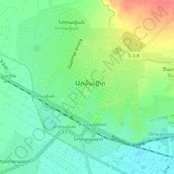
Name: Armavir topographic map, elevation, terrain.
Location: Armavir, Armavir Province, Armenia (40.13835 44.01804 40.17018 44.07961)
Average elevation: 869 m
Minimum elevation: 849 m
Maximum elevation: 911 m
Other topographic maps
Click on a map to view its topography, its elevation and its terrain.
Vagharshapat
Vagharshapat, Vagharshapat region, Armavir Province, Armenia
Average elevation: 868 m
Vagharshapat
Armenia > Armavir Province > Vagharshapat > Vagharshapat
Vagharshapat, Vagharshapat Boundary, Armavir Province, 1101, Armenia
Average elevation: 873 m