
Diepsloot Nature Reserve topographic map
Interactive map
Click on the map to display elevation.
About this map
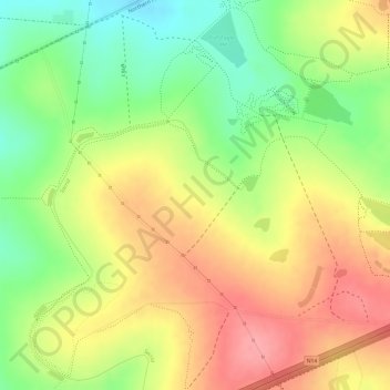
Name: Diepsloot Nature Reserve topographic map, elevation, terrain.
Average elevation: 1,356 m
Minimum elevation: 1,301 m
Maximum elevation: 1,401 m
Other topographic maps
Click on a map to view its topography, its elevation and its terrain.
Johannesburg Ward 96
Johannesburg Ward 96, Randburg, City of Johannesburg Metropolitan Municipality, Gauteng, RSA
Average elevation: 1,394 m
Johannesburg Ward 86
Johannesburg Ward 86, Randburg, City of Johannesburg Metropolitan Municipality, Gauteng, RSA
Average elevation: 1,697 m