
Vaals topographic map
Interactive map
Click on the map to display elevation.
About this map
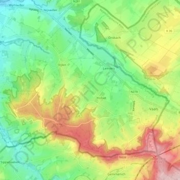
Name: Vaals topographic map, elevation, terrain.
Location: Vaals, Limburg, Netherlands (50.75276 5.92054 50.80344 6.02785)
Average elevation: 215 m
Minimum elevation: 123 m
Maximum elevation: 347 m
Other topographic maps
Click on a map to view its topography, its elevation and its terrain.
Maastricht
Netherlands > Limburg > Maastricht
Maastricht, Limburg, Netherlands, 6211CS, Netherlands
Average elevation: 101 m
Dagstrand De Grote Hegge
Netherlands > Limburg > Thorn
Dagstrand De Grote Hegge, Thorn, Maasgouw, Limburg, Netherlands
Average elevation: 24 m
Horst aan de Maas
Horst aan de Maas, Limburg, Netherlands
Average elevation: 27 m