
Storms River topographic map
Interactive map
Click on the map to display elevation.
About this map
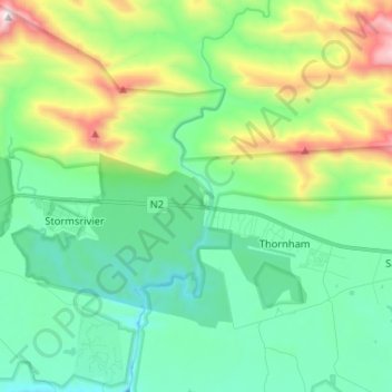
Name: Storms River topographic map, elevation, terrain.
Average elevation: 376 m
Minimum elevation: 63 m
Maximum elevation: 1,253 m
Other topographic maps
Click on a map to view its topography, its elevation and its terrain.
Kareedouw
RSA > Eastern Cape > Kou-Kamma Local Municipality
Kareedouw, Kou-Kamma Local Municipality, Sarah Baartman District Municipality, Eastern Cape, RSA
Average elevation: 392 m