
Twistniet Mountain Nature Reserve topographic map
Interactive map
Click on the map to display elevation.
About this map
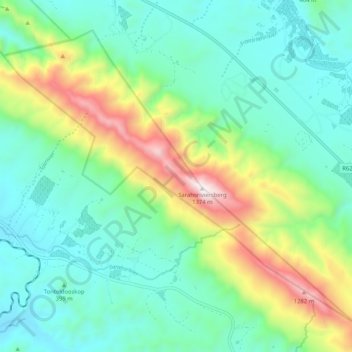
Name: Twistniet Mountain Nature Reserve topographic map, elevation, terrain.
Average elevation: 523 m
Minimum elevation: 203 m
Maximum elevation: 1,380 m
Other topographic maps
Click on a map to view its topography, its elevation and its terrain.
Langeberg Ward 10
RSA > Western Cape > Langeberg Local Municipality
Langeberg Ward 10, Langeberg Local Municipality, Cape Winelands District Municipality, Western Cape, RSA
Average elevation: 256 m
Dassieshoek Nature Reserve
RSA > Western Cape > Langeberg Local Municipality
Dassieshoek Nature Reserve, Dassieshoek, Langeberg Ward 6, Langeberg Local Municipality, Cape Winelands District Municipality, Western Cape, RSA
Average elevation: 737 m
Bloupunt
RSA > Western Cape > Langeberg Local Municipality
Bloupunt, Langeberg Local Municipality, Cape Winelands District Municipality, Western Cape, RSA
Average elevation: 903 m