
Bunia topographic map
Interactive map
Click on the map to display elevation.
About this map
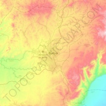
Name: Bunia topographic map, elevation, terrain.
Location: Bunia, Irumu, Orientale, Ituri, Democratic Republic of the Congo (1.40205 30.08788 1.72205 30.40788)
Average elevation: 1,271 m
Minimum elevation: 651 m
Maximum elevation: 1,952 m
It lies at an elevation of 1275 m on a plateau about 30 km west of Lake Albert in the Albertine Rift, and about 25 km east of the Ituri Forest.
Other topographic maps
Click on a map to view its topography, its elevation and its terrain.
Ngezi
Democratic Republic of the Congo > Ituri > Bunia
Ngezi, Mbunya, Bunia, Ituri, Democratic Republic of the Congo
Average elevation: 1,251 m